


Course description
The Ultra Solo 66km was described by a 2023 runner as “trail running heaven”. It will see you circumnavigate kunanyi and head down and up each valley! It features the famous Organpipe Track, with spectacular views down to niplaluna/Hobart, the kunanyi pinnacle plateau, technical single tracks through beautiful snow gums, as well as old growth eucalypts, rainforests, technical scrambling – and so much more!
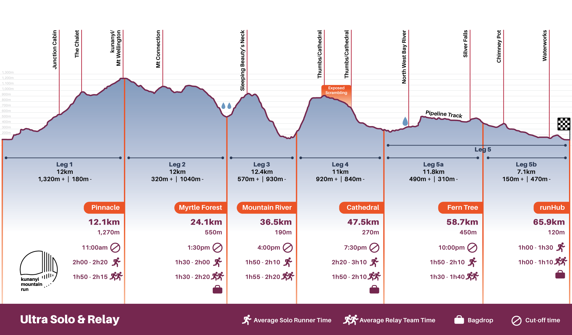
The Solo course is the same as for the Ultra Team relay course, with 5 different legs. Check out the detailed course leg descriptions below:
runHub to Pinnacle | 12.0km | 1,320m ↑ | 180m ↓ | Map
Straight out of the runHub, past Cascade Brewery on the paddocks, a bit of tarmac, then you enter the silver peppermint forests and fire trails of kunanyi’s foothills. Turn onto the single trail and immerse in the ferns and waterfalls, climbing up Myrtle Gully Track. Passing Junction Cabin, the sunlight returns and the climb continues through the big eucalypts and past Crocodile Rock. Open dolerite boulder fields can test agility but don’t miss the views! Merge with Old Hobartians track and keep climbing through sub alpine scrub to the Chalet. Cross the road (under direction of the course marshals) and onto the flowing and relatively flat and well built Organ Pipes Track. Don't miss the epic views of Hobart and beyond and the organ pipes above. Time to climb again up the almost fully stone pitched Zig Zag track, up through alpine scrub and onto the kunanyi pinnacle plateau, the alpine heath and the regularly howling wind! Most seasoned Hobart trail runners don jackets and beanies up on the last Z turn, before rounding out. Jump into the aid station, hand over your race number to your leg 2 runner and you’re done!
With by far the most climbing of all the legs, this one is for those that like the vert a little more than most! Lucky the best kept secret of trail running is that you don’t actually run uphill much, as power hiking is often faster and much more energy efficient. Check this article out for technique
Pinnacle to Myrtle Forest | 12.0km | 320m ↑ | 1,040m ↓ | Map
Off The Pinnacle and straight down Pinnacle Road for a couple of kilometres before heading off down Big Bend Fire Trail and over the back of the mountain, with views of the Collins Peak and the side of Sleeping Beauty. Turn on to the technical single track over Mt Connection through alpine marsh, snow gums, and the famous Tassie waratah. A short rock slab slide and flowing tight single trail brings you out on to East West Fire Trail and the climb up on to the shoulder of Collins Bonnet, before dropping down on the single track through old growth eucalypts and rainforest. Then it's down through a couple of creek crossings, and more waterfalls and ferns to the Myrtle Forest Aid Station.
If you like the alpine vegetation, epic views, a bit of exposure, and enjoy technical single track and a some descending - then this leg is for you.
Myrtle Forest to Mountain River | 12.4km | 570m ↑ | 930m ↓ | Map
After a kilometre of flat to warm up, climb straight back up on single track through the rainforest, massive old growth eucalypts and waterfalls. Then it's back up to the snow gums and alpine scrub to climb Collins Fire Trail and the undulating East West Fire Trail, curving across Sleeping Beauty’s neck. Then the epic views down the Huon Valley and out to Bruny Island emerge, and you drop down the biggest descent of the run on Mountain River Trail – an old and rocky fire trail. Down, down, down it goes on the southern side of kunanyi; back through similar vegetation types except there aren't any old growth trees on this side – you may even see the stumps of the old giants and an old saw pit site of two. You’ll know your quads a little better after the 900 metre (straight down) descent, which pops you out on the gravel Mountain River road for a few kilometres, through the farming valley of Mountain River and to the aid station, located on a generous farmer's property.
This leg is for the downhill frothers! The diversity of landscapes, views, mountain and valley mean that those who run this leg will connect deeper with the mountain, its history and culture. It's a must-do leg for everyone once they get the downhill quads sorted!
Mountain River to Cathedral | 11.0km | 920m ↑ | 840m ↓ | Map
Traversing farm land ridges on the foothills of Montagu Thumbs, sing to the cows and admire Sleeping Beauty to the north from whence Leg 3 came. At the Wellington Park boundary, it's time to climb the steep Old Montagu Trail through dry - then wet eucalypts - rainforest, and back up into the alpine scrub and snow gums. The trail is no longer passable to vehicles with some great scree and erosion gullies, but ATVs still make it up to Norris Hut! You’ll enjoy our track maintenance work (thanks to all the volunteers!) for the next while – the dense low beura bush was ‘fun’ to bash through just a couple of months ago. Then it's on to one of the most spectacular sections of the entire route, the single track of Montagu Thumbs traverse – a real skyrunning experience of sharp and exposed ridge line, with 360 degree views down the Huon, Channel, Bruny, South Arm, Kingston, the southern slopes of kunanyi with the NW Bay River below. Wellington Falls is also just out of view but you can see where it is by reading the terrain, and a little look back to Mt Montagu. The traverse is technical, scrambly, with a heap of short sharp ups and downs. It's also a little exposed to heights in parts. The traverse ends on top of Cathedral Rock, and then comes off the ridge line and bombs down the hill, on a steep single track then old fire trail - zig zagging all the way down to NW Bay River and the aid station on a wood carver's property.
This leg is for the more adventurous trail runner, who really likes scrambling around mountains and feeling the air space on both sides drop away. With equal parts of both solid climbs and descents, this is for the mountain goat.
Cathedral to Fern Tree to runHub | 18.9km | 640m ↑ | 780m ↓ | Map
Heading back up the Cathedral Rock track for a couple of kilometres, high-fiving the crew on the way down, you cross the NW Bay river bed and head up a short(ish…) steep climb. It's up a fire trail, dubbed Siphon’s ugly cousin, and it to connects to the Pipeline Track. Stride out the next 7km on this comparatively flat and smooth track (just watch the occasional root!) to Fern Tree Bower, then it's uphill through a ferny gully with an old water supply race (that's a water channel) to Silver Falls. Continue up the steep and technical Reids track to Radfords, then traverse downhill onto the classic Fern Glade track down to Fern Tree and the mid leg aid station.
Continuing down the Pipeline Track past a couple of century old stone arches supporting the water pipeline, you’ll turn in at Halls saddle. Past an old quarry, and zigzagging up (check out the view of the organ pipes!), then down a short single track through silver peppermint forest around Chimney Pot hill. Cross the road and back down on to the pipeline track to the old stairs down Gentle Annie Falls. You’re now in Waterworks Reserve and will take the single track around the dam that supplies drinking water to Hobart. Zig then zag gently up the last hill to Huon Rd, then bomb down rough steep tracks to Cascade paddocks, the home straight, and the finish line and runHub! Enjoy the recovery area with hearty food and drinks available for purchase including some classic Tasmanian beverages.
While this leg is the longest at 20km, it is considered to be equally achievable as the other legs due to the lovely stride out on Pipeline Track and less elevation than other legs. This leg will suit the speedy runners out there.
Each leg is a challenge and an epic achievement in it’s own right!
Download leg descriptions
Course video
3D Fly through
Qualifying
The Ultra solo is suitable for experienced trail runners and previous race experience will be needed for qualification - click here for qualifying run info.
Minimum 18yrs age, unless by exception and with parent/guardian consent; contact: hello@kunanyimountain.run
FAQs:
kunanyi pinnacle is typically 10 degrees cooler than the city.
Logistics
Please see the logistics table below for information on distances, times, aid stations, support crew accessibility and drop bag options:
| Leg | Section | Leg km | Cumulative km | Ascent | Descent | Cut off | Avg time | |
|---|---|---|---|---|---|---|---|---|
| 1 | runHub (Wellesley Park) Pinnacle |
12.0km | 12km | 1,320m | 180m | 11.00am | 2:00-2:20 | |
| 2 | Pinnacle Myrtle Forest |
12.0km | 24.1km | 320m | 1,040m | 1.30pm | 1:30-2:00 | |
| 3 | Myrtle Forest Mountain River |
12.4km | 36.5km | 570m | 930m | 4.00pm | 1:50-2:10 | |
| 4 | Mountain River Cathedral |
11.0km | 47.5km | 920m | 840m | 7.30pm | 2:20-3:10 | |
| 5a | Cathedral Fern Tree |
11.2km | 58.7km | 490m | 310m | 10.00pm | 1:50-2:10 | |
| 5b | Fern Tree runHub (Wellesley Park) |
7.1km | 65.9km | 150m | 470m | 12.00am | 1:00-1:30 | |
| 5 | Cathedral runHub (Wellesley Park) |
18.9km | 65.9km | 640m | 780m | 12.00am | 2:50-3:40 |
Key: Aid station Drop bag Additional support crew access
We care about your safety whilst out there – check out the MANDATORY GEAR LIST here